"We lost the link" is not an event — it's a number
In post-mortems of lost aircraft, one phrase keeps coming up: "the link dropped." It describes the outcome and explains nothing. A radio link is really the difference between two quantities: how much power reached the receiver, and how little it needs to still decode a packet. That difference is measured in decibels, it is called link margin, and as long as it stays positive, you have a link.
The useful part is that this number can be computed in advance — on the bench, before the flight. And once you compute it, you can see where the scarce decibels come from and where they go.
We packaged that into an interactive trainer: "How a Drone Loses Its Link". Four live simulations running in the browser, no backend, no dependencies. It is the second part of a series — the first one, "How an Autopilot Thinks", was about what happens inside the flight controller. This one is about what happens between the controller and the transmitter when there are ten kilometres, a hill and someone else's radio station in between.
Why transmit power is the worst investment
The first instinct when a link degrades is to buy a more powerful transmitter. Decibel arithmetic explains why that barely helps.
Free-space path loss is FSPL = 32.44 + 20·log₁₀(f) + 20·log₁₀(d). The logarithm means doubling the distance costs exactly 6 dB — and so does doubling the frequency. The reverse is equally true: to gain 6 dB you must quadruple transmit power. Going from 100 mW to 400 mW buys you a factor of two in range, and only if nothing else is in the way.
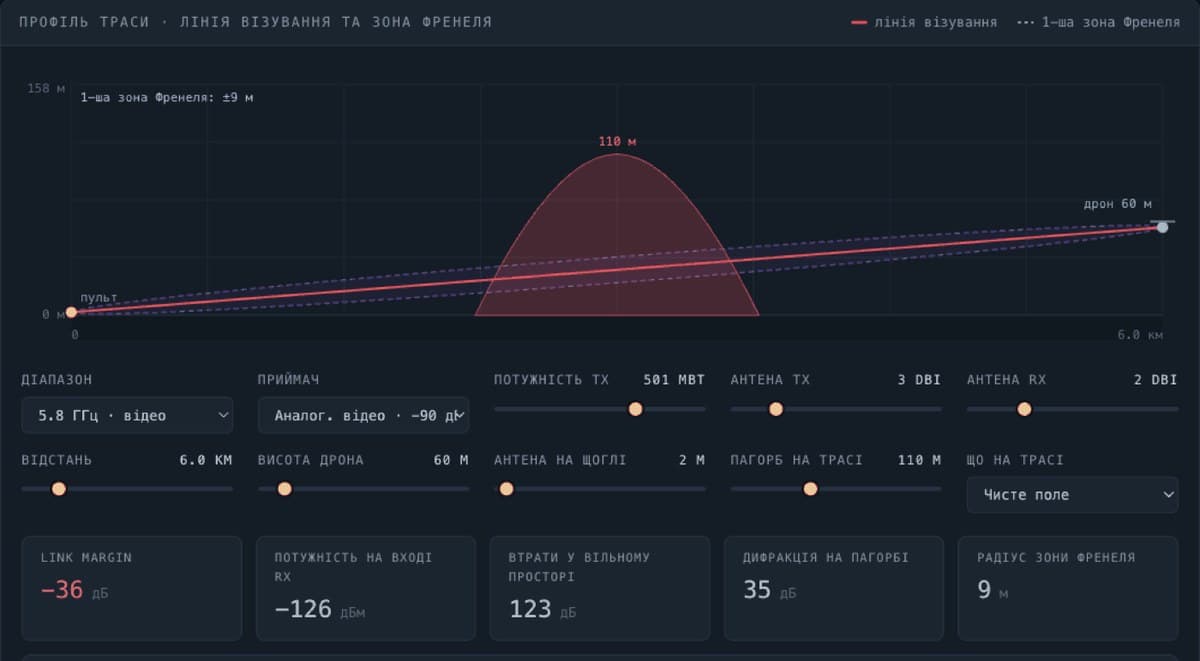
Something else almost always is. A radio wave does not travel as a thread but as a cigar-shaped volume around the straight line — the first Fresnel zone, whose mid-path radius is 17.32·√(d₁·d₂ / (f·D)) metres. At 2.4 GHz over eight kilometres that is roughly sixteen metres. If a hill, a treeline or a rooftop blocks more than 40% of that volume, the signal starts falling apart — even when everything looks perfectly visible.
The trainer has a preset that demonstrates this better than any explanation: a hill on the path, line of sight formally intact, and diffraction eating 35 dB. That is more than any legal power increase will ever give back. The same 35 dB return for free if you raise the aircraft or put the antenna on a mast.
Hence the rule the graph makes obvious: altitude is cheaper than watts.
Why jamming wins on geometry, not power
A jammer does not "overpower" your transmitter. It is simply closer.
Power falls with the square of distance, and that asymmetry decides everything. A station two kilometres from the aircraft delivers a signal to the receiver front end that is tens of decibels stronger than your transmitter working from ten kilometres away — typically around 30 dB in the jammer's favour. The spectrum view makes it visible: a wide block of interference raises the noise floor, the receiver's effective sensitivity threshold creeps upward, and the wanted signal ends up underneath it.
One nuance the model computes honestly: barrage jamming spreads its power across its entire bandwidth. If your channel occupies 0.5 MHz and the jammer covers 40 MHz, only 1/80 of its energy lands in your receiver — a 19 dB discount. Spot jamming puts everything into the channel, but it has to find that channel first.
The practical conclusion is counterintuitive but follows directly from the formulas. Adding 3 dB at the transmitter means doubling the watts for almost no result. A directional antenna (+10 dB), a lower packet rate (+7 dB of sensitivity for ELRS 50 Hz versus 500 Hz) and a change of band are worth tens of decibels. You find decibels in the antenna and the operating mode, not in the transmitter's power rating.
The expensive scenario is not "GPS lost" — it's "GPS lying"
The third module is a flight simulation where you cut links with buttons and watch what the firmware does. The same event — loss of control link — produces four different endings depending on what was configured on board.
Betaflight without a rescue mode stops the motors where the signal disappeared. The same Betaflight with GPS Rescue climbs and returns to the launch point. ArduPilot without a position estimate switches to a controlled landing, preserving both the airframe and its coordinates. None of this is news — but seeing the three outcomes side by side on one map lands differently.
The interesting part begins when GPS does not disappear but lies. An aircraft with return-to-home enabled dutifully turns and flies toward the spoofed point — straight past its real home — and lands there. Formally the failsafe performed flawlessly; it was simply handed a different map. Firmware that validates position jumps in its estimator rejects the untrusted source and lands in place: airframe intact, coordinates known.
Which is the module's central claim: validating the position matters more than the return mode itself. And separately, the second most common cause of losses: a home point recorded before a confident fix. The aircraft honestly flies back to a place that does not exist. Checking that on the ground takes five minutes.
Your own transmitter as the main source of interference
The fourth module covers the fact that half of all "unexplained link losses" originate not from the outside, but from fifteen centimetres away.
The classic case: the second harmonic of a 1.2 GHz video transmitter lands squarely in the 2.4 GHz control band. The aircraft jams its own receiver, and no electronic warfare is required. The same applies to the third harmonic of 433 MHz falling onto 1.3 GHz video. The band planner checks the selected pair for self-jamming and harmonic overlap and explains what to do about it.
There is also a less obvious rule about the order of failures. Video should degrade before control does — then you lose the picture but keep authority over the aircraft. The reverse order, where the operator can see the target but the airframe no longer responds, is the worst of the available outcomes.
On honesty in teaching tools
One detail from development deserves a mention. The first version reported a range of 825 kilometres for the long-range preset. The formula was not wrong — that is genuinely what the link budget allows. The Earth simply curves away much sooner: the real limit there is about 97 kilometres, set by the radio horizon, d = 4.12·(√h₁ + √h₂) with the standard refraction correction.
We capped the calculation at the horizon and made the label state which constraint is currently binding. A teaching tool that lies plausibly in small things is worse than no tool at all: it builds confidence exactly where confidence is unwarranted.
For the same reason every limitation of the model is stated openly: the path is treated as flat with a single obstacle, multipath and antenna radiation patterns are not modelled, and time in the failsafe simulation runs six times faster than real. This does not replace field measurements — it is a way to see which quantities drive which outcomes.
Try it
The trainer is open and free: yak-dron-vtrachaye-zvyazok.vercel.app. Source is on GitHub under MIT — take it, take it apart, make it better.
Everything runs in your browser: one HTML file, no backend, no dependencies.